Loading
  • Facebook
  • Twitter
  • Instagram
  • 0Shopping Cart
Cahokia Mounds State Historic Site
  • HOME
  • Society
    • About
    • Membership Benefits
    • Mound Builder Award
    • Land Acquisition Program
    • Planned Giving
    • Cahokian
  • LEARN
    • Picture Gallery
    • EDUCATE
    • EXPLORE
      • CENTRAL PALISADE
      • STOCKADE
      • WOODHENGE
      • Mound Gallery
      • SATELLITE VIEW
    • ABOUT
  • PLAN YOUR VISIT
    • HOURS & ADMISSION
    • GET DIRECTIONS
    • SCHEDULE GROUP
    • INTERPRETIVE CENTER
    • TRAIL MAP
    • ACCOMMODATIONS
    • ACTIVITY PERMIT
    • AUGMENTED REALITY PROJECT
  • News
  • EVENTS
  • SHOP
    • Shop All
    • Educational Materials
    • Cahokia Mounds Souvenirs
    • Native American Arts & Crafts
    • Kids Corner
    • Home & Wellness
  • SUPPORT
    • One-Time Donation
    • Monthly Giving
    • VOLUNTEER
    • JOIN
    • RENEWALS
  • Menu
  • Cahokia Mounds Timeline

PreviousNext
123456789101112

Explore

Cahokia Mounds

One of the greatest cities of the world, Cahokia was larger than London was in AD 1250. The Mississippians who lived here were accomplished builders who erected a wide variety of structures from practical homes for everyday living to monumental public works that have maintained their grandeur for centuries.

EXPLORE MOUNDS

All 76
All 76 /CAS 0 /Employment 0 /Events 0 /Indian Market Days 0 /Mounds 1 - 25 21 /Mounds 26 - 50 24 /Mounds 51 - 75 25 /Mounds 76 - 104 6 /Nature/Culture Hike 0 /News 0

Mound 1

Mound 1
This easternmost mound within the presently defined…

Mound 2

Mound 2
Just to the north of Mound 1, the Patrick Map shows…

Mound 3

Mound 3
The Patrick Map locates what appears to be a large,…

Mound 4

Mound 4
Patrick shows Mound 4 to the west of Mound 3 but…

Mound 5

Mound 5
This is one of the larger mounds shown on the Patrick…

Mound 6

Mound 6
The easternmost mound of what is presently called the…

Mound 7

Mound 7
On the Patrick Map, Mound 7 is in direct association…

Mound 8

Mound 8
On the Patrick Map, Mound 8 is indicated as a large,…

Mound 9

Mound 9
Located between N1214-1249 and E130-156, Mound 9 has…

Mounds 10 and 11

Mound 11 Photo Source: Illinois State Museum
Although these…

Mound 12

Mound 12
Mound 12 is illustrated on the Patrick Map as a small,…

Mounds 13, 14, 15, and 16

These four mounds, as numbered on the Patrick Map and followed…

Mound 17

The Patrick Map shows Mound 17 as an irregularly shaped mound…

Mound 18

Just northwest of Patrick's Mound 35 is what appears to be a…

Mound 19

To the east of Mound 18 on the Patrick Map of 1876 is a line…

Mound 20

As mapped by Patrick, Mound 20 is an ovalshaped platform mound…

Mound 21

Mound 21 is one of the smaller mounds in this east west alignment.…

Mound 22

Mound 22 is shown on Patrick's map to be a large, conical mound;…

Mound 23

According to Patrick's map, Mound 23 is a small, conical mound…

Mound 24

Moorehead describes Mounds 24 and 25 in his 1929 report as the…

Mound 25

Patrick shows Mound 25 as a small, conical mound slightly larger…

Mound 26

This is the last mound in the east-west row extending from Mound…

Mound 27

Just south of Mounds 24-26 is a group of four mounds-53, 28,…

Mound 28

Shown by Patrick as a large, circular-based, flat-topped mound…

Mound 29

Mound 29 The smallest of a group of three mounds (27, 28, and…

Mounds 30 and 31

These mounds are intimately associated with each other. On the…

Mound 32

Mounds 32 and 33 form one of the associations of square platforms…

Mound 33

As Noted above, this large, conical mound stood on the northeast…

Mound 34

Mound 34 is located to the east of Monks Mound in a complex of…

Mound 35

On Patrick's map, Mound 35 is indicated as a conical mound west-northwest…

Mound 36

Comparable to the pairing of Mounds 32 and 33 is that of Mounds…

Mound 37

Shown as a small, conical mound adjoining the northwest corner…

Mound 38 – Monks Mound

The largest mound at the Cahokia site, the largest man-made earthen…

Mound 39

Located just west of Monks Mound is Mound 39, a small, rounded…

Mound 40

Mound 40 was identified by Patrick as a small, conical mound…

Mound 41

This mound is directly west of the south half of the Monks Mound.…

Mound 42

Known as the Merrell Mound, this is one of the largest and best…

Mound 43

Patrick noted a small, conical mound to the west of Mound 42…

Mound 44

Apparently this mound was originally a rectangular, flat-topped,…

Mound 45

One of the rectangular mounds at the Cahokia site is Mound 45,…

Mound 46

In 1876, when Patrick was making his map of the Cahokia site,…

Mound 47

Mound 47 is one of the site's smaller mounds. It was mapped by…

Mound 48

Mound 48 is one of the larger mounds of the Cahokia site. Its…

Mound 49

About 100 meters (328.1 feet) south of Monks Mound is a tumulus…

Mound 50

This mound is one of a series (Mounds 50, 51, 54, and 55) running…

Mound 51

Although almost totally destroyed, Mound 51— known locally…

Mound 52

Elongate in form, Mound 52 is shown by Patrick to be parallel-sided…

Mound 53

Mound 53 is the southernmost of a row of what were probably conical…

Mound 54

Mound 54 is indicated by a slight elevation in the subdivision…

Mound 55 – Murdoch Mound

Known as the Murdock Mound, Mound 55 was still standing in 1940…

Mound 56

Aside from Monks Mound, Mound 56 is one of the most illustrated…

Mound 57

There are many points of confusion regarding mound numbers on…

Mound 58

Directly south of Mound 42, Patrick indicates a rather large…

Mound 59

About 500 meters (1,640 feet) directly south of Monks Mound are…

Mound 60

Associated with Round Top, Mound 60 is a large, rectangular platform…

Mound 61

Both Mounds 61 and 62 are in association with a large borrow…

Mound 62

Mound 62 is located near the large series of borrow pits in the…

Mound 63

The Patrick Map shows Mound 63 as a small, conical mound in the…

Mound 64

Sometimes known as True Rattlesnake Mound, Mound 64 is located…

Mound 65

Moorehead (1929: 83-84) suggests that Mound 65 is "South 9°…

Mound 66

Referred to by Moorehead (1929) as the Harding Mound and by the…

Mound 67

Southeast of the largest borrow pit at the Cahokia site is another…

Mound 68

Just to the south of Mound 67 is what appears to be a flat-topped…

Mound 69

This small mound is part of what is known today as the Rouch…

Mound 70

This mound is also part of the Rouch mound group located in the…

Mound 71

Although noted by Patrick, this small mound does not appear on…

Mound 72

This mound, about 850 meters (2,789 feet) south of Monks Mound,…

Mound 73

This small mound, directly south of Mound 42, was first noted…

Mound 74

Patrick does not show a mound near Mound 58, but Moorehead does…

Mound 75

p>Although clearly visible today just south of Highway 40, this…

Mound 76

A small, square mound, located on the old bank of Cahokia Creek…

Mound 77

On Moorehead's 1929 map, four mounds-39, 77, 40, and 41-form…

Mound 78

Mound 78 is also known as the Jondro Mound. In the 1923 map,…

Mound 79

Moorehead's 1929 map shows Mound 79, which he named the Mackie…

Mound 80

Mound 80 on the Moorehead Map of 1923 is numbered 75 on the 1929…

Mound 81

Just south of Mound 64 and the Southern Railroad tracks, Moorehead…
Load more
Central Palisade

Central Palisade

Summer Research Summary — 2000

Three projects took place at Cahokia Mounds this summer, and all were continuations of research that took place during last two years. Two projects were coordinated by Dr. John Kelly, through the Central Mississippi Valley Archaeological Research Institute (CMVARI), and the third was directed by Dr. William Woods of Southern Illinois University Edwardsville.

Cahokia Artifacts

Mound 34:
Back in the mid-1950s, Greg Perino of the Gilcrease Institute in Tulsa, Oklahoma, excavated some exploratory trenches into Mound 34, a relatively small mound a few hundred yards east of Monks Mound, and which is one of a cluster of mounds that appear to define a plaza area. Perino found many exotic, or non-local, materials, including fancy pottery, copper, galena, shark’s teeth, and sea shells.

The latter was most intriguing as some of the shells were fragmentary pieces of ceremonial cups that had been engraved with designs associated with the Southeastern Ceremonial Complex (SECC), normally found south of here from Georgia to Oklahoma. Dr. James Brown of Northwestern University is exploring the hypothesis that the origins for some of the SECC concepts may have originated at Cahokia and spread southward, and that research into Mound 34 may elucidate information in support of this.

This exotic material led Dr. John Kelly, of Washington University, and Dr. Brown to believe this was a special elite area outside of the stockade wall-enclosed Central Precinct. Thus, they did testing to relocate Perino’s old trenches with the plan to reexamine the soil profiles and features, which had not been mapped in detail, and review the context of these materials, as well as to better determine the age of the mound and its stages of construction. They led field schools from Washington University and Northwestern, and were assisted by another field school class from the University of Missouri-St. Louis under Timothy Baumann.

After two seasons of searching, the west wall of one of Perino’s trenches was located last year and nearly 12 meters of the wall was exposed this year and mapped in detail. A, dark, organic, artifact laden layer defined the base of the mound, apparently soil borrowed from a nearby midden (village debris) deposit. Above this was additional mound fill of lighter soils with basket loading deposits evident. Two large pre-mound pit features were visible below the base of the mound with lots of debris in them. A couple wall trenches from structures were also evident. During the past two seasons, they also recovered more fancy pottery, nuggets of copper, a drilled shark’s tooth that may have been part of a war club, a painted animal bone, mica, and marine shell, including small fragments with some engraved designs.

Perhaps the most intriguing find was what appears to have been an intentionally placed dedicatory deposit of 7 shells, possibly once in a container or wrapped up together, just below the base of the mound. One was a local mussel shell, but the others were whole or partial specimens of sea shells, including lightning whelk and fighting whelk (conch). Kelly and Brown plan to return next summer to further explore this intriguing mound.

West Palisade:
Dr. Mary Beth Trubitt continued her pursuit of the palisade (stockade) wall around the western side of the central ceremonial precinct. Excavations during the 1960s through the 1980s had located four wall constructions on the east and south sides. Trubitt had identified some segments of the deep trenches that had been dug to support the wall posts to the south and west of the Twin Mounds during the last two seasons.

Last year, she found what appeared to be part of the wall heading toward Mound 48, in the northwest corner of the Grand Plaza, and her plan was to see if they could identify where it turned west to go around that mound. With a field school from Henderson State University, where she is now headquartered with the Arkansas Archaeological Survey, Trubitt expanded some of last year’s excavation units and opened some new ones. Some of the new units were placed west of the other excavations, where remote sensing tests using electrical resistivity had suggested there were subsurface disturbances suggestive of possible wall trenches.

Unfortunately, these did not turn out to be parts of the palisade, but other features, and it is not clear at this point just where the wall does turn. Future research in this area should clarify where the wall(s) continue through this part of the site.

Monks Mound:
SIU Edwardsville continued its program of trying to understand more about Monks Mound, following up on work they began with the repairs to the west slump and the installation of the new stairs up the front over the past few years.

Dr. William Woods led the project, which involved field school students from SIUE, SIU Carbondale under Dr. John Sexton, and also students from the University of Goettingen, Germany. Most of their project at Cahokia focused on the First Terrace of Monks Mound to test the hypothesis of its being a late addition to the front of the mound. They also are trying to identify other possible features, such as structures or pits, that lie below the surface.

Excavations during the 1960s-70s had identified historic period (mid 1700s) occupation, burials and a French chapel location on the west side of the First Terrace, all relating to an occupation by Illini (Illinois) Indians long after the Mississippians had left. The testing for the new stairway in the late 1990s also identified some large refuse pits near the center of this terrace, full of the remains of deer, bear, turtles, swans, fish, and other animals, as well as French period ceramics, gun parts, glass and knives. Recently, SIUE and SIUC have been using resistivity and other methods on the eastern portion of this terrace to see if they can identify additional features.

They also have been taking vertical cores across the terrace. The preliminary results seem to confirm that the First Terrace was indeed a late addition to the front of the mound, based on detected soil changes and angles of slope. The other resistivity test results are still being analyzed, but it will be interesting to see what they determine. No additional testing was done in the area of the stone mass under the Second Terrace, due to time and equipment restraints, but some work may be done this fall.

Stockade

Stockade

References to walled villages in historic accounts of southeastern Native Americans led archaeologists to look for a fortification at the great capital of Mississippian culture. Aerial photographs taken of fields near Monks Mound in the 1920s and 1930s revealed light linear streaks that might have been soil disturbances from an ancient wall.

Listen

Early Stockade (Round Bastions)
2nd and later Stockades (Square Bastions)

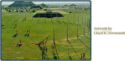
Excavations begun in 1966 eventually confirmed that an enormous, two-mile-long stockade surrounded the central portion of Cahokia. The wall appears to have been started aroundA.D. 1100 and then rebuilt three times over a period of 200 years. Each construction required 15,000-20,000 oak and hickory logs, one foot in diameter and twenty feet tall. The logs were sunk into a trench four to five feet deep and were likely supported with horizontal poles or interwoven with saplings. The stockade walls may have been covered with clay, as well, to protect them from fire and moisture.

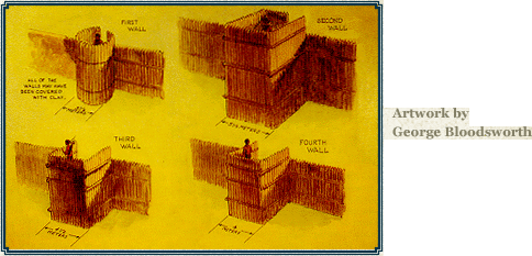
Because there is no evidence of invasion at Cahokia some people question the purpose of the Stockade. To a degree, it probably served as a social barrier; however, three things lead most archaeologists to believe that it was primarily a defensive structure: the great height of the wall; the presence of evenly spaced bastions, projections from which archers could shoot arrows; and evidence that portions of the wall were hurriedly built, cutting through residential areas, as if danger was imminent.

Woodhenge

Woodhenge

Fascinating information about the people who once built the great prehistoric city of Cahokia was revealed accidentally during excavations in the early 1960s. Professional archaeologists were trying desperately to save archaeological information which was to be destroyed by the construction of an interstate highway, which was later rerouted.

After a summer of intense excavation, Dr. Warren Wittry was studying excavation maps when he observed that numerous large oval-shaped pits seemed to be arranged in arcs of circles. He theorized that posts set in these pits lined up with the rising sun at certain times of the year, serving as a calendar, which he called WOODHENGE. After further excavations by Wittry and other archaeologists, more post pits were found where predicted, and evidence that there were as many as five Woodhenges at this location. These calendars had been built over a period of 200 years (A.D. 900-1100). Fragments of wood remaining in some of the post pits revealed red cedar had been used for the posts, a sacred wood.

The first circle (date unknown), only partially excavated, would have consisted of 24 posts; the second circle had 36 posts; the third circle (A. D. 1000), the most completely excavated, had 48 posts; the fourth, partially excavated, would have had 60 posts. The last Woodhenge was only 12, or possible 13 posts, along the eastern sunrise arc(if it had been a complete circle, it would have had 72 posts). Building only the sunrise arc might indicate that red cedar trees had become scarce.

It is not known why the size and location of the circles, and the number of posts was constantly changed—perhaps to include more festival dates or to improve and increase alignments.

Only three posts are crucial as seasonal markers—those marking the first days of winter and summer (the solstices), and the one halfway between marking the first days of spring and fall (the equinoxes). Viewing was from the center of the circle, and several circles had large “observation posts” at that location, where it is likely the sunpriest stood on a raised platform. Other posts between the solstice posts probably marked special festival dates related to the agricultural cycle. The remaining posts around the circle have no known function, other than symbolically forming a circle and forming an enclosure to hold the sacred Woodhenge ceremonies. There have been suggestions some posts had alignments with certain bright stars or the moon, or were used in predicting eclipses, and others have suggested Woodhenge was used as an engineering “aligner” to determine mound placements, but none of this has been proven convincingly.

The most spectacular sunrise occurs at the equinoxes, when the sun rises due east. The post marking these sunrises aligns with the front of Monks Mound, where the leader resided, and it looks as though Monks Mound gives birth to the sun. A possible offertory pit near the winter solstice post suggests a fire was burned to warm the sun and encourage it to return northward for another annual cycle and rebirth of the earth. This probably marked the start of the new year.

The third circle (A.D. 1000) was reconstructed in 1985 at the original location. The circle is 410 feet in diameter, had 48 posts spaced 26.8 feet apart (9 are missing on the west side, removed by a highway borrow pit). The posts were 15-20 inches in diameter and stood about 20 feet high. Red ocher pigment found in some of the post pits suggests the posts may have been painted. The post pits averaged 7 feet long and just over two feet wide, sloping from the surface at one end to a depth of four feet at the other, forming a ramp to slide the posts down to facilitate their raising.

Satellite View

Satellite View
img-satelliteView

  • CONTACT US
  • SITE CREDITS
  • LINKS
  • TERMS & CONDITIONS
30 Ramey Street Collinsville, IL 62234 | 618-346-5160 | © Cahokia Mounds State Historic Site
  • Facebook
  • Twitter
  • Instagram
Scroll to top