
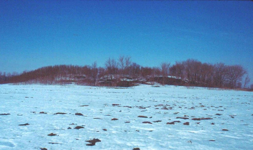
Mound 66
Referred to by Moorehead (1929) as the Harding Mound and by the US Geological Survey as the Rattlesnake Mound, Mound 66 is one of the largest mounds at the Cahokia site. What was locally referred to as Rattlesnake Mound (Mound 64) was partially destroyed by construction of the railroad tracks. The name seems to have been transferred to the Harding Mound by the USGS surveyors, causing some confusion.
Mound 66 is a long, ridge-topped mound, one of the few of this type at the site. Its form is marred by an unfilled trench that Moorehead cut through the mound in the 1920s. On recent maps the mound appears to have a notch through the middle. Mound 66 is one of the higher mounds at the site. McAdams, in 1882, gives a height of 30 feet (9.1 meters), whereas Thomas, in 1894, gives 20 feet (6.1 meters), and Peterson-McAdams in 1906, 25 feet (7.6 meters). Using the base elevation as the 129 meter (423.2-foot) contour, the 1966 UWM Map shows a height for this mound of 7.4 meters (24.3 feet). Using the same base elevation, the north-south dimension is 51 meters (167.3 feet) and the east-west dimension is 132 meters (433.1 feet). A. J. Throop (1928: 38-39) describes the mound in 1928:
Rattlesnake Mound is approximately five hundred feet long, two hundred feet wide, thirty feet in height. The top is beautifully rounded, furnishing an ideal situation for the four roomy tents of the explorers party. The surrounding ground is very low, with, however, a well-defined graded way running due north. Messrs. Jesse and James Ramey, who called to view the work, stated that this graded pass was extended north through their land toward the mounds immediately south of old Cahokia [Monks Mound].
When Mr. Taylor surveyed the mound he was amazed at the accuracy of the contour maintained by the builders, and expressed himself as puzzled that so great a pile of earth could be made so nearly true to keep its contour throughout the ages. At points two hundred feet east of center and two hundred feet west of center, less than one tenth of a foot difference in elevation was found. [Throop 1928: 38-39]
Due to fear that the railroad track just north of this mound would be expanded and destroy the area, Mound 66 was made the focus of intensive excavations sponsored by Moorehead’s party. The work was carried out by an engineer, J. L. B. Taylor, and Moorehead’s report is mostly a quoting of Taylor’s report on the mound excavations. Taylor carefully surveyed the mound in a grid system with the center line of the grid directly through what was thought to be the center of the mound. The plan of excavation was to put a 50-foot-wide (15.2-meter) trench, starting at the edge, through the mound along the north-south, or minor, axis. This plan would allow for a one-to-one slope of the side wall, so that by time the trench reached the bottom of the mound it would be only a few feet wide. This was, however, decided against since opening such a cut would have called “for removal of the office tent which although all four tents had been crowded against each other was nevertheless close against Stn. 16, major axis.” (Moorehead 1929: 74). Instead the trench was cut 15 to 20 feet to the west, somewhat off the center of the mound. Excavations through the top of the mound revealed burials. These burials are described as follows:
About 3 P.M., May 27, the slip team uncovered the knees of a human skeleton at a depth of three feet . . . and was then moved to the opposite edge of the cut in order not to interfere with the work of laying this skeleton bare by means of trowels. When the bones had all been cleaned off, they were given a coat of wet Spanish whiting to bring them in relief, and were then photographed, and left in place …. As there were traces of wooden coffins and number of nails and metal buttons and buckles found with these, we concluded that these burials were, probably, those of Frenchmen or early settlers.
They were reburied west of the mound, each accompanied by a bottle containing a note from myself telling where and under what circumstances they had been found. [Moorehead 1929: 74-75]
At a lower level, approximately 3 feet (0.9 meters) below the surface, a large number of burials were found. According to Taylor’s estimate, there were remains of at least 140 burials found in a poor state of preservation; traces of bones and teeth were all that remained.
Along with one of the burials was a chunky stone or discoidal, reportedly found on the face of the skeleton. A drawing in Moorehead’s report (1929: Plate xxxvi) gives rather specific dimensions for it although the description of the drawings says it was drawn from memory. It shows a chunky stone approximately 3 inches (7.6 centimeters) in diameter; it is well turned out with flattened edges to the rim and a well-defined and large central depression on both sides. There is no indication of what kind of stone it is.
Besides the excavations, auger holes were drilled into the mound on both its east-west and north-south axes, and Moorehead presents a drawing (1929: Plate xxciii) to show the nature of mound construction as he could determine it from these tests. Moorehead thought that Mound 66 was built mostly of what he called gumbo. As nearly as can be determined, he is referring to a bluish black, very sticky, clay-like soil that is found in the southern portion of the Cahokia site just under the plow zone. Of this material, Moorehead asks:
Why were so many mounds built of gumbo? It is difficult to handle even our own men using modern steel shovels find it heavy and wearisome to remove. Possessed of naught but stone and shell hoes, digging sticks, and baskets or skin bags, the removal and transportation of sufficient gumbo to erect Mound 66 was a Herculean task. [Moorehead 1929: 104-106]
In any given area, it is probable that mounds made of this so-called gumbo were probably the first built, as this is the material which the Indians came upon first. Using that concept, Moorehead suggests that certain mounds were built earlier than others because no artifacts were found in their fill and because they were chiefly composed of black gumbo.
As to the function of ridge-top mounds in general and of Mound 66 in particular, Moorehead speculates:
It is too narrow on top for large wigwams or temples. The auger tests nearly two hundred to the base did not indicate the level or burnt floor common in mortuary tumuli. Beyond No.66 toward the north is an elevation flanked by two ponds or depressions. Old observers used to call this a causeway leading to other mounds. There being no village-site worthy of the name around No. 66, why the causeway? The burials found by Engineer Taylor a few feet below the surface, down the southern slope were made after the mound had been constructed. There appear to be no burials, altars, or distinct stratigraphy in the body of the mound. It must remain one of the mysteries of Cahokia and we may be pardoned again for referring finally to the series of complete and detailed maps drawn by Mr. Taylor, which cover every possible fact or circumstance of mound construction of this remarkable tumulus…. We have never believed that all these structures were erected within a short space of time, individually or as a group. Number 66 seems to show completion within limited dates, there being no sodlines. [Moorehead 1929: 104-106]
