Mound 34 is located to the east of Monks Mound in a complex of mounds identified by Melvin Fowler as the Ramey Group. More recently the overall configuration of the group has been designated the Ramey Plaza. 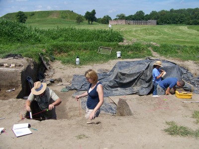
The earliest depiction of this relatively small mound is as a small conical-shaped edifice north of mounds 33 and 34 on Patrick’s 19th century map of Cahokia. Today the outline of Mound 34 is blurred by nearly two centuries of plowing. Early measurements indicated a height of about 3 meters (10 ft). Today it is approximately 2.5 meters (8 feet) with the upper area having been removed by the farmer in the 1950s.
The first documented excavations occurred in l950, when a University of Michigan Museum of Anthropology, crew placed three large (5 by 10 foot) test pits into Mound 34. They were interested in obtaining data that would refine the chronology for the site. Over 25,000 ceramic sherds were recovered with no clear evidence that there was any significant difference in the mounds sequence. Of interest though was an engraved piece of a marine shell cup that was recovered along with a piece of repousse copper from the test pit on the northeast side of the mound. Charcoal was recovered from a feature associated with the submound village that yielded a carbon date of A.D. 1152 +/- 200 years (Griffin and Spaulding 1951). Although Michigan had conducted other investigations at Cahokia and the surrounding region they did not continue further work at the site.
In 1956, the Thomas Gilcrease Foundation of Tulsa, Oklahoma, carried out a project under the direction of a local amateur, Gregory Perino. Perino opened a large block excavation approximately 20 by 30 meters into the north face of the mound along with a 4 by 12 meter north-south trench across the mound summit. Perino identified a number of large Mississippian structures under the mound including a 6 by 15 meter refuse pit that was nearly 1 meter in depth. This pit contained numerous exotic items consisting of ” awls, needles, and worked bone pieces . . . including a few projectile points and a drilled shark’s tooth. Pottery fragments were all of the Old Village culture except several that are foreign to Cahokia . . . The predominating vessel type in the trench was plates. There were many, all of the Ramey Incised rim, both narrow and broadly decorated. Nearly a dozen efigy [sic] duck heads were found, some red, others black, body sherds were not as numerous” (Perino n.d.:2). Also of interest was a negative painted, black and white platter with a design motif similar to the designs on the engraved shell cups from Spiro in eastern Oklahoma.
North of the mound two copper workshops were identified. A schematic map and profile maps were produced from his excavations. Assisting in the production of these maps was a graduate student from the University of Michigan, Dan Morse. In the south profile Perino identified an early mound stage upon which there was evidence of flooding. He also recognized a terrace or apron on its north and west sides. At the juncture of the terrace with the main mound were deposits referred to by Perino as “Ceremonial Fires.” The materials recovered from this deposit included fragments of engraved shell along with a drilled shark’s tooth, an imitation shark’s tooth made of chert, numerous arrow points, shell beads, novaculate spud fragments, and a number of wooden artifact fragments.
The primary mound was a rectangular platform. Perino noted the presence of a building with a large circular hearth on its summit. To the north of Mound 34 was an extensive borrow area whose deposits had been exposed by a flash flood in 1955. Materials from this deposit included whole ceramic vessels and other exotic ceramics related to Mound 34.
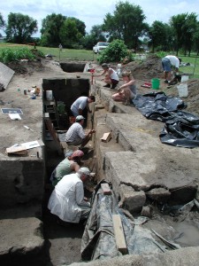
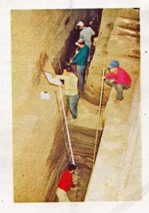
In the summer of 1998 with support from the Cahokia Mounds Museum Society a new project was proposed that focused on Mound 34, directed by James Brown, PhD, of Northwestern University and John Kelly, PhD, of Washington University. Based on the earlier work of the 1950s, our goals have been to (1) relocate the earlier 1950s excavations, (2) identify Perino’s “ceremonial fires” from which the engraved shell and other ritual items came, (3) locate the refuse trench described by Perino, and (4) locate the copper workshops he identified. This work, which has continued each summer since then, has relocated most of the limits of the earlier investigations and provided new information through our remapping of the older profiles.
Perino’s main block excavation, along with two of the University of Michigan units, have been located during the course of the recent excavations. The focus for this up-coming summer is on locating one of the copper workshops. The following summarizes the results of our work through 2006 in terms of the mounds construction sequence.
Pre-mound activities consisted primarily of large wall-trench structures some of which date to about AD 1200. Just before the mound’s construction nearly a foot of the original occupation area was removed. The copper workshop also predate the mound’s construction but appears to be associated with this cleared surface. Although we have been unable to verify this important area we have recovered from the backdirt a number of raw copper-nuggets and small pieces of worked copper. Another feature dug into this surface was the “refuse trench” identified by Perino. We have located the western end of this unusual feature, which appears to have been a small borrow pit. It appears from our excavations this pit began to be filled in naturally through erosion before it was cleaned out and then lined with a thin-layer of black clay. Presumably this was part of a ceremony that involved feasting especially the consumption of deer and other animals. Also present were 58 species of bird including numerous raptors and dominated by swans. The filling of this pit involved the disposal of numerous serving dishes such as effigy bowls and plates in the trench.
Just south of the pit on the stripped surface was perhaps one of the most intriguing finds of what appears to have been an intentionally placed dedicatory deposit of 7 shells, possibly once in a container or wrapped up together. One was a local mussel shell, but the others were whole or partial specimens of seashells, including lightning whelk and a hawk wing whelk (conch).
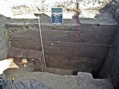
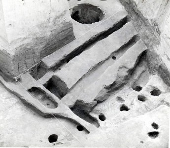
The filling of this pit coincided with the creation of the first mound platform, whose height was about 80 cm. The top of this platform was scraped cleaned. Across the surface was a deposit of flood-like sediments derived from the erosion of the large rectangular platform constructed on top of the platform. No structures have been identified from the top of this platform although a large post was placed into the platform to a depth of approximately 2 meters in depth as the platform was being constructed. The post was then subsequently removed.
Perino identified a building with a large central hearth on top of the primary platform. Pictures taken from one of his profiles provide indications that the building was burned. Our excavations have exposed the northern terrace’s junction with the primary platform. It is in this area that Perino recovered over a dozen fragments of engraved shell. In cleaning the profile we also recovered another fragment of the engraved shell. Perino documented the terrace on the north and west sides of the primary mound. One of the University of Michigan’s test units was placed over the junction of a terrace on the east-side as well.

 Mound 37 appears not only on the Patrick Map but on all later maps of the site. It has been seriously deflated by plowing and constant use so that its height today is barely discernible on the UWM Map contours and on recent aerial photographs. However, in earlier times, it apparently had a much greater height, as the McAdams Map of 1882 and the Thomas Map of 1894 both give 10 feet (3.05 meters) as its height. In 1906 the Peterson-McAdams Map records a figure of 6 feet (1.8 meters). In any case, the height is always shown to be less than Mound 36. This contrasts with the other paired mounds, such as Mound 32 and 33, where the conical mound was taller than the associated platform mound. No excavations have been reported in either Mound 36 or 37.
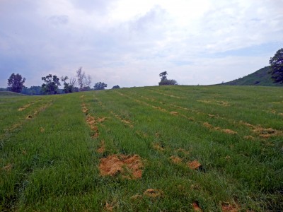 While Patrick’s map shows quite a number of rectangular or square mounds with a fairly consistent east-west or north-south orientation, Mound 36 is aligned slightly east of north, as is Monks Mound. McAdams confirms the Patrick delineation of this mound, since he illustrates Mound 36 as square with straight, well-defined sides, about 15 feet (4.6 meters) high, and with a summit area of between 1 and 2 acres (0.4 to 0.8 hectares).
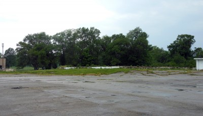 contemporary size or exact grid location can be documented. Estimates of height from earlier map s vary from 20 feet (6.1 meters) (McAdams 1882) to 5 feet (1.5 meters) (Peterson-McAdams 1906). The latter estimate coincides with Moorehead’s observations in 1921 (Moorehead 1922), when he describes Mound 30 as an extensive elevation on the east side of Mound 31 not over 5 feet in height. Unlike Patrick, Moorehead describes this mound as square, 180 feet (54.9 meters) on each side.
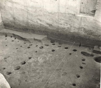
 unds. Moorehead’s trench extended due west 55 feet (16.8 meters). At 35 feet (10.7 meters) west he sunk a test pit 10 feet, 5 inches (3.2 meters) deep and found disturbed earth, charcoal, and small pottery sherds at 7 feet, 3 inches (2.2 meters). He dug another pit at 55 feet and found the disturbed area extended to 7 feet, 8 inches (2.3 meters). During the excavation he found animal bones, broken artifacts, and pottery. He also discovered lumps of burnt clay containing impressions of reeds or rushes, probably from the building of aboriginal houses in the area. Nearer the base of Mound 31, he excavated, by means of a horse team and scraper, a pit 30 feet (9.1 meters) square and 8 feet (2.4 meters) deep. He noted a hard, burned layer of floor beneath the base line similar to the formation noted in the hand-dug trench. Moorehead, on the basis of his excavations, was unable to determine whether Mound 31 was a burial structure or merely a foundation for houses or ceremonial lodges.
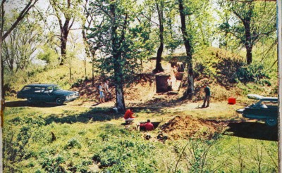
 led and Grandpa’s Store built. Grandpa’s Store and parking lot now occupy the sites of Mound 31 and Mound 30. As part of the work of salvage archaeology before the construction of Grandpa’s Store, Joseph Caldwell, for the Illinois State Museum, conducted a stratigraphic excavation into Mound 31. It revealed a rather complete stratigraphic sequence of the various phases of Cahokia development. The material from these excavations is currently in the Illinois State Museum. It should be noted that Moorehead (1923: 47) thought Mound 30 really a part of Mound 31. All of the earlier maps, however, treat them individually. He perhaps based his interpretation on the effects of erosion, cultivation, and use attendant with the casino and farm buildings.