Mound 25

Patrick shows Mound 25 as a small, conical mound slightly larger than Mound 24. The USGS map shows a circular elevation in the same relative position, which probably represents Mound 25. Field surveys indicate that the base of Mound 25 is intact and accounts for a rise in the street in the middle of the 300 block on Yale Street in State Park Village. Available information on this mound has already been discussed under Mound 24.

Mound 24

Moorehead describes Mounds 24 and 25 in his 1929 report as the Edwards mounds. Mound 24 is shown on the Patrick Map as a small, conical mound in the east-west line of Mounds 19 to 26. It is almost equally distant from Mound 22 to the west and Mound 25 to the east. Mounds 24 and 25 may be associated with Mound 22, which is a larger, oval shaped platform mound. Patrick’s is the only early map that locates Mound 24. Ground surveys indicate that the base of what appears to be Mound 24 is in part of a yard of 3209 West Point Street in State Park Village. Portions of the mound extend into adjoining lots. Moorehead reports he excavated in Mound 24, where he found an extended skeleton at a depth of 4 feet (1.2 meters). Near its head were some flint chips, two or three flint knives, and pot sherds. His report suggests that he dug a trench 60 feet (18.3 meters) long and 20 feet (6.1 meters) wide through the mound and that throughout this excavation were fragments of broken pottery. According to Moorehead (1922), the preliminary Cahokia survey was made in September to October 1921, and it was at this time that he explored the Edwards mounds (particularly Mound 24). He did not identify them by number until writing later reports (Moorehead 1922: 21-22).

In April 1922, aerial photos of the Cahokia site were taken by Lieutenants Goddard and Ramey (Hall 1968), and Moorehead was once again actively engaged in archaeological investigations at this time. However, the aerial photos (Crook 1923: Figure 6) do not show any excavations in what appears to be Mound 24 but do show large areas of excavations in what must be Mound 26. The large, round excavated area appears to almost completely cover the mound, and slightly to the northeast is what appears to be a rectangular excavation. There is a possibility Mound 25 is disturbed, as there is a whitish line running east-west along its southern edge. Moorehead does mention the possibility of an excavation in what may have been Mound 26, although he calls it Mound 25:

East of this [Mound 24], distant about 400 feet, is another mound, Number 25, about 7 feet in height. We dug a trench through the center and sunk 8 or 10 test pits, finding no burials but discovered scales of copper on the base line. About one-third of this mound remains to be explored. [1922: 22]

The aerial photographs and the above citation suggest that he returned and again excavated into Mound 26 in 1922. However, in his later publication (1929: 37), Moorehead identifies this as Mound 25 and says that it remains to be explored. Through all of this Moorehead apparently had Mounds 24, 25, and 26 confused, since in his early work he had not applied the Patrick numbers to the mounds. It is my assumption that he started excavations in the fall of 1921 and only later utilized the Patrick Map of the site and applied its numbering system. There is some confusion in Moorehead’s notes in regard to locations of mounds and which mounds he actually had excavated.

The aerial photos explicitly illustrate excavations on Mound 26 and trenching in Mound 25. Hence, Moorehead’s reference to Mound 24 may actually apply to Mound 25, and his testing of a mound 400 feet to the east would refer to Mound 26. Scaling from the Patrick Map, the distance between Mounds 25 and 26 is much closer to 400 feet than is the distance between Mounds 24 and 25.

Mound 23

According to Patrick’s map, Mound 23 is a small, conical mound (comparable in size to Mound 19) directly north of Mound 22. It appears on the UWM Map with a base elevation of 129 meters (423.2 feet) between N330-360 and E834866. That indicates a north-south dimension of 30 meters (98.4 feet) and an east-west dimension of 32 meters (105 feet). The height shown by the UWM Map is 1.1 meters (3.6 feet). The earlier McAdams, Thomas, and Peterson-McAdams maps are not helpful in identifying Mound 23. Mound 23 is a conical mound that is apparently related to Mound 22. There are no records of excavations in Mound 23.

Mound 22

Mound 22 is shown on Patrick’s map to be a large, conical mound; it is part of a triangle made by Mound 22 on the west, Mound 24 on the east, and Mound 23 on the north. He suggests that Mound 22 was a large, oval-to-round platform mound. The base of Mound 22 is at an elevation of 129 meters (423.2 feet) and is located between N268 298 and E841-876 on the UWM Map. Its north-south dimension is 30 meters (98.4 feet) and its east-west dimension is 35 meters (114.8 feet). These measurements conform very well with Patrick’s description of a slightly oval form with its major axis east-west. The top elevation of the mound today is 129.5 meters (424.8 feet), giving it a height of 0 .5 meters (1.6 feet) . Both McAdams and Thomas show 15-foot (4.6 meters) heights, while the Peterson-McAdams Map of 1906 shows only 5 feet (1.5 meters).

Mound 21

Mound 21 is one of the smaller mounds in this east west alignment. Patrick indicates it was a small, conical mound. Visible on some of the recent aerial photographs, it appears today as a very minor contour elevation, one apparently partially covered over by slope wash or disturbed by plowing from Mound 22 to the east.

Mound 20

As mapped by Patrick, Mound 20 is an ovalshaped platform mound with the long axis east-west. It has the same general shape on the UWM Map. Assuming the 127-meter (416.7-foot) contour as the base elevation of this mound, it is located between N236-300 and E70-772. This gives a north-south dimension of 64 meters (210 feet) and an east-west dimension of 68 meters (223.1 feet). The elevation on the top of the mound is 128.5 meters (421.6 feet), a height today of 1.5 meters (4.9 feet). The earlier maps indicated a much greater height. The McAdams Map of 1882 gives a height of 15 feet (4.6 meters) and Moorehead, in 1923, 4 feet (1.2 meters). The latter height conforms rather closely to present data, suggesting that most of the disturbance of this mound took place in the late nineteenth century.

As discussed above, Moorehead’s excavations were probably largely into Mound 20. The following summarizes some of Moorhead’s findings. Most notable were a number of burials. The depths of the skeletons varied from 2.5 to 6.5 feet (0.8 to 2.0 meters), and, except for one or two, all were extended. One-third were accompanied by pottery vessels. One skeleton was buried with four pots: a bowl, a jar, a dish, and a dipper-like object with a long, slender projecting handle decorated with sun symbols, a typical bean pot of the Cahokia area. Identification of the sun symbols is based upon the illustration published by Moorehead (Moorehead 1929: Plate xvii). Other pottery vessels, mussel shells, and rough flint objects were also buried with skeletons. None of the skeletons were well preserved. All the interments appeared to be on the same level or base line and were possibly buried in the village debris rather than the mounds. Moorehead also mentions that most of the burials appeared to be women; unusual, he thought, since both sexes should be found in the cemetery areas (Moorehead 1923: 17-19, 1929: 41-49).

In regard to the Mound 20 burials, Perino (1959) mentions that two burials on the fringe of Mound 20 and one burial beneath Mound 20 had horizontally filed teeth. Perino was surprised that Moorehead made no mention of notched or filed teeth among the Mound 20 burials since he is certain some skulls exhibited that type of filing. On the basis of the kind of pottery uncovered with these burials, Mound 20 is considered to be of a late date in the sequence of mound building at the Cahokia site. Mound 20 was one mound cited by Reed et al. (1968: 146-147), who stated that most of the mounds were built after the completion of Monks Mound.

Mound 19

To the east of Mound 18 on the Patrick Map of 1876 is a line of mounds numbered 19 to 26. The first of these is Mound 19, which is located to the northeast of Mound 34.

The remnant of Mound 19 today appears as a lobe in the 127-meter (416.7 foot) contour line. It is a very small rise in the ground, reduced greatly by plowing. Patrick indicates that Mound 19 is a conical mound with a very small area on top. The McAdams (1882) and Thomas (1894) maps both give a height of 10 feet (3.05 meters), but later maps give only 5 feet (1.5 meters) (Peterson-McAdams 1906, Moorehead 1923). There are some discrepancies in the location of Mound 19 on the earlier maps, but once again Patrick’s location is accepted due to the care of his survey and because it corresponds with the UWM Map and aerial photographs.

Moorehead excavated in this area, reporting (1923) that because of cultivation, the edges of these mounds overlap. He also reports excavating a trench “of over 250 feet from the center of Mound 19 well into Mound 21.” However, on the UWM Map 250 feet (76.2 meters) would cover only the distance from the center of Mound 19 to the center of Mound 20 and would definitely not extend to Mound 21. It is possible that Moorehead may have assumed that Mound 20 actually included Mounds 20 and 21, since the distance between Mounds 19 and 20 on the UWM Map is about 79 meters. If that is the case, Moorehead’s description of material found in Mounds 19, 20, and 21 would only apply to Mound 20. For example, Moorehead makes the following comment:

About 150 feet from the west end of our trench, at a depth of three feet, were many fragments of spades and hoes, or digging tools of reddish chert. Why these were all broken we do not know. There were enough fragments to comprise fifteen or twenty of the tools, and about them were ashes and burnt earth. Fifteen feet beyond was a mass of pulverized galena Iying in ashes. [1923:17-19]

Assuming the west end Moorehead’s trench was in Mound 19,150 feet east of that would be Mound 20. Therefore, this cache of chert hoes would pertain to Mound 20. Other remains found by Moorehead are discussed in the description of Mound 20. Perino (1959), who excavated in the Ramey Field northeast of Monks Mound in the 1950s, mentions a burial “just west of the adjoining Mound 19. ” This was a female with notched edge filed teeth.

Mound 18

Just northwest of Patrick’s Mound 35 is what appears to be a small, round mound with a flat top, Mound 18. Mound 18 is indicated on the UVVM Map as a lobe in a contour line, and it has the appearance today of a low dome approximately 1 meter (3.3 feet) high. The change in appearance since Patrick’s time is undoubtedly due to cultivation over the last one hundred years. Earlier maps estimate Mound 18’s height as from 6 to 10 feet (1.85 to 3.05 meters), the McAdams and Thomas maps both give a height of 10 feet (3.05 meters). Early maps do not agree on the location of the mound. However, the Patrick Map was more carefully surveyed than either the Thomas or Peterson-McAdams maps, and the location indicated by Patrick corresponds more closely to contemporary aerial photos and contour data.

Early excavations were conducted in the vicinity of Mound 18 and the mounds that form a line heading east *from it, Mounds 19 to 26. Stephen Peet made the following reference in The American Antiguarian:

Mr. Ramey, the owner of the mound, speaks about digging in one part of the field and finding heaps of bones eight feet deep, and says that the bones are everywhere present. The workmen who were engaged in digging ditches for under draining had a few days before they came upon large quantities of pottery and skeletons of large size, but had carelessly broken them instead of preserving them. As to the character of the pottery and the patterns contained in them, we noticed some remarkable resemblance’s between the pieces exhumed here and those which are found in the stone graves of Tennessee. One specimen was especially interesting. It represented a squirrel holding in its paws a stick, the teeth placed around the stick as if gnawing it, the whole making a handle to the vessel. We noticed also a frog shaped pipe made from sandstone and many other animal-shaped and bird-shaped forms. The object which impressed us most was a sandstone tablet, which contained figures very much like those found upon the inscribed tablets taken from one of the mounds of the Etowah Group in Georgia. [Peet 1891: 9-10]

Mound 17

The Patrick Map shows Mound 17 as an irregularly shaped mound to the northeast of Monks Mound. The Patrick Map shows the mound with straight east and west sides, but the north and south sides progress from northeast to southwest in a step-like pattern. On the McAdams Map (1882), Mound 17 is shown as a square mound 15 feet (4.6 meters) high and in the same relative position indicated on the Patrick Map. Thomas (1894), however, shows Mound 17 to be conical, small in area, 20 feet (6.2 meters) high, and much further north than the two previous maps. The Peterson-McAdams Map (1906) shows Mound 17 as circular, 10 feet high (3.1 meters), and further to the west than either Patrick or McAdams indicate.

The USGS topographic map, which is based on surveys conducted in the early 1930s, shows a circular elevation in the area indicated by both the Patrick and McAdams maps, suggesting that the mound still existed in the early part of this century. The contours indicated on the USGS map suggest an oval mound with its major axis east-west and a height of 10 feet (3.1 meters). Today there is no major elevation in that area, the mound has disappeared. There is, however, a small elevation just to the north of the northeast corner of Monks Mound that may be a remnant of Mound 17. Since the area in question has been owned by the state since 1930, it is doubtful that Mound 17 was bulldozed during road building or other construction, although a small road encircling Monks Mound does make a turn in the general vicinity.

Gregory Perino (personal communication) has several times mentioned a flood in the 1940s that cut through low-lying land behind Monks Mound carrying away several feet of earth in that region. It is Mounds 13, 14, 15, and 16 possible that the area of Mound 17 has been eroded by flooding. Charles Bareis of the University of Illinois at Champaign-Urbana, digging just to the west of where Mound 17 should have been, did find indications of fill and construction work building up the level of the ground. Whether this is a remnant or basal portion of Mound 17 or some other phenomenon remains undetermined.

Because Mound 17 was apparently located near the northeast corner of Monks Mound, it might have been associated with the burial discovered by William McAdams in 1882:

We were working at our investigation, one beautiful day in the early spring, in a field at the base of the great Cahokia mound, when our probe struck something which proved to be one of these burial vases…. The next day, beneath the grateful shade of the great temple mound which towered a hundred feet above us, we took from that ancient tomb, which was not two rods square, over one hundred perfect vessels. [McAdams L895: 179]

Moorehead further excavated the area nearly 40 years later and described the burials found: Both of Mr. McAdams’ sons, as well as W. J. Seever, Esq., visited the scene of our operations and indicated where they thought Mr. McAdams had excavated. During that season (1921) we had a crew of twenty-one men at work and we examined the ground some 600 feet northeast of Monks Mound where the witnesses thought McAdams made the discovery. We also extended operations, working rather intensively here and there for a radius of three hundred yards. Some of the trenches were fifty feet in length. Broken human skeletons were found scattered here and there, probably where Mr. McAdams had made finds. We recovered one flexed burial accompanied by half of a bowl. There was another partial burial a few feet to the west. The ground about it was much disturbed. Above both burials was a layer of hard baked red earth some two feet from the surface. The disturbed earth extended from three to as much as five feet in depth. [1929: 28]

Mounds 13, 14, 15, and 16

These four mounds, as numbered on the Patrick Map and followed by Moorehead, must be considered as a group. There are major discrepancies between the Patrick locations of these mounds and indications on current aerial photographs and contour maps of the area. Patrick shows these basically as two pairs (13-14 and 15-16) just north of Monks Mound. Mound 14 is a large, oval-shaped mound, and 13 is a small, apparently conical mound. Mound 16 is a large oval with a platform top, and Mound 15 is a large (compared to 13) conical mound. Recent maps and field studies indicate, however, that there are remnants of two mounds in the positions Patrick numbers Mounds 14 and 16, and another mound to the west, approximately halfway between what Patrick labels Mounds 13 and 15. I can identify only three mounds in this group, not the four that Patrick has numbered.

On some aerial photographs, soil disturbance to the east of the line between Mounds 14 and 16, and approximately in a line with Mound 5, might indicate a fourth mound in the group. Whether this fourth mound’s location is accepted or not, it is still quite a different arrangement than Patrick’s. For now, Mounds 14 and 16 are considered two positively identified mounds, and they will be described first.

Mound 14 as mapped by Patrick is the northern most mound of the group. It does not appear as a distinct contour on the UWM Map. Field observations indicate a contour rise in a roughly round and dome-shaped form in this area. Patrick indicates that Mound 14 had a conical summit and oval base with the east-west axis longer than the north-south axis. He located this ,mound directly north of Mound 15 and south of Mound 9. The McAdams Map of 1882 also places it north of Mound 15 and south of Mound 9 and indicates a height of 10 feet (3.1 meters), as does the Thomas Map of 1894. Moorehead reports trenching this mound in April 1922, giving its dimensions as 180 feet(55.5 meters) north-south, 110 feet (33.9 meters) east-west, and a height of 5 feet (1.5 meters). He states that a road ran through the area along the crest of Mound 14. He also “saw a sunken depression in the center of the mound from end to end.” In his probing Moorehead found “a few pieces of stone, no pottery and some broken bones.” Directly to the south of Mound 14 is Mound 16, which is clearly defined on the 1966 UWM Map. Assuming its base is at 125 meters (410.1 feet), it is located between N452-482 and E96-128, giving a north-south dimen sion of 30 meters (97.3 feet) and an east-west dimension of 32 meters (103.8 feet). The top of the mound is at 125.7 meters (412.4 feet), indicating a height of 0.7 meters (2.3 feet). The McAdams Map of 1882 gives a height of 10 feet (3.1 meters) as compared to the Thomas Map of 1894, which gives 15 feet (4.6 meters). The Peterson-McAdams Map of 1906 gives a height of 6 feet (1.85 meters). The discrepancies between the late nineteenth century and the present are probably due to extensive cultivation of the area and flooding that has deposited silt in this region. This mound group is located in the lowest-lying land in the whole Cahokia site, an area indicated on most maps as swamp. It is possible that the bases of these mounds are buried and that their true height is somewhat greater. The locations of these mounds suggest that the area may have been drier at the time of their construction. The Patrick, McAdams, Thomas, and Peterson-McAdams maps show great discrepancies in the locations of these mounds. Swampy conditions and the difficulties of surveying the area in those early days may account for the differences.

Another contour and mound elevation on the 1966 UWM Map is located approximately halfway between Mounds 14 and 16, directly west of a line that aligns it with Mound 5. This is designated Mound 15 on the UWM Map, although it may not be Patrick’s Mound 15. Assuming a base elevation of 125 meters (410.1 feet), Mound 15 is located between N472-510 and W5-25, giving a north-south dimension of 38 meters (124.7 feet) and an east-west dimension of 20 meters (65.6 feet). The top elevation is 125.4 meters (411.4 feet), giving a height of 0.4 meters (1.3 feet). The height given by the McAdams and Thomas maps is 10 feet (3.1 meters), while the Peterson-McAdams Map of 1906 gives a height of 5 feet (1.5 meters). Since this may not be the same Mound 15 referred to by Patrick, I cannot comment on its change in shape and form. The Mound 15 on the 1966 UWM Map is oval with the long axis north-south. This shape is confirmed by aerial photographs taken from 1933 to the present that show a soil mark of approximately this shape and dimensions.

There is no evidence of Patrick’s Mound 13 on the UWM Map. There is a possible mound to the east of the axis between Mounds 14 and 16 in a location of would be comparable to the presumed location of Mound 13, but it shows up on only on a few aerial photographs and cannot be confirmed in the field Present data suggest that this group is represented by three mounds in a basically triangular pattern with its north-south line from Mounds 14 to 16. W of the median point of this line stands Mound 15. The number 13 is retained to represent a mound indicated by Patrick that can not be identified today.

Mound 12

Mound 12

Mound 12 is illustrated on the Patrick Map as a small, conical mound west of both Mound 11 and Sand Prairie Lane. Unfortunately, this mound does not appear as a distinct contour on the 1966 UWM Map. Consequently, there is little data on Mound 12 except Patrick’s suggestion of its conical shape and the appearance in that area of a small, oval rise on the UWM Map. Mound 12 is reported by Moorehead (1923: 45, 1925: 98). His comments were summarized in Titterington (1938: 7):

There is a small mound about 1/4 of a mile north of Monks Mound from which a large number of unfinished celts were taken about 30 or 40 years ago. All were pecked out into a fairly good shape except for some on which the bit had not been formed. The largest weighed about 25 pounds.

Mounds 10 and 11

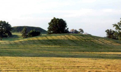
Mound 11 Photo Source: Illinois State Museum

Although these two mounds are numbered separately on the Patrick Map, and are shown as two separate structures on the Moorehead and UWM maps, I consider them two levels of a single structure. Mound 10 is a lower platform to the east, and Mound 11 is a large, conical, higher eminence on the west half of this location. For convenience, however, I will discuss them separately and then discuss their overall configuration.

Using 127 meters above sea level (416.7 feet) as the base, the Mound 10 portion extends from coordinates N1198 to N1244 and from E40 to E75. The E40 line, where Mound 11 begins, is taken as the division between the two areas. The Mound 10 section measures 46 meters (150.9 feet) north-south and 35 meters (114.8 feet) east-west.

With 127 meters as the base line, it appears that the Mound 10 portion is 2.0 meters (6.5 feet) high. That figure varies greatly from previous heights for these mounds, but it appears that even in the earlier days there was confusion over their configuration. The McAdams Map of 1882 shows a square-shaped Mound 10 extending from the east side of Mound 11. No height is given. The Thomas Map of 1894 shows Mound 10 as a square platform mound larger than Mound 11 in area but 15 feet (4.6 meters) lower in height. The Peterson-McAdams of 1906 merges Mounds 10 and 11 into one large, oval mound.

The Mound 11 portion of this structure, from a base elevation of 127 meters, is 7.5 meters (24.6 feet) high. That figure corresponds with the McAdams Map of 1882 and the Thomas Map of 1894, both of which give a height of approximately 30 feet (9.1 meters). Moorehead, in 1921, thought that the base line of this mound was about 35 feet (10.7 meters) below the summit. He also believed it had been a conical mound approximately 50 feet (15.2 meters) in height before 15 to 16 feet (4.6 to 4.9 meters) was removed around 1900. Moorehead further indicates that the mound was probably about 400 feet (121.9 meters) in diameter with the top platform area about 75 by 56 feet (22.9 m by 17.1 meters). The 1966 UWM Map shows the top to be 22 meters by 17 meters (72 by 56 feet), which corresponds rather closely with Moorehead’s measurements. Mound 11 was extensively excavated by Moorehead in 1921 when he cut into the north side with a trench 60 feet (18.3 meters) long and 30 feet (9.1 meters) deep. References to Moorehead’s excavations an be found in his 1923 and 1929 publications. In the mid 1950s, Preston Holder of Washington University excavated extensively on the west side of Mound 11 and into the area of Mound 10, which he considered a platform extending eastward from Mound 11.

In summary, I consider Mounds 10 and 11 to be a single unit, namely a large circular platform on the west (Mound 11) with a platform extending to the east (Mound 10). If that is the case, this structural unit is one of the few mounds with more than one terrace at the Cahokia site. This is contrasted with the other mounds in the Kunneman group (Mounds 6-11), which are combinations of oval or circular platforms and cone-shaped mounds with an intervening or connecting platform.

Preston Holder, from Washington University, conducted excavations and analysis in 1950s, which were well documented but not published. Timothy Pauketat reexamined the data and published the results in the book Temples for Cahokia’s Lords: Preston Holder’s 1955-1956 Excavations of Kunnemann Mound, Memoirs of the University of Michigan Museum of Anthropology, No. 26, 1993.

Written by Bill Iseminger

Mound 9

Mound 9

Located between N1214-1249 and E130-156, Mound 9 has a north-south dimension of 35 meters (114.8 feet) and an east-west dimension of 26 meters (85.3 feet). Its present height is 0.7 meters (2.3 feet). On the Patrick Map, Mound 9 has a squarish base and a conical top and it rises from its base to a rounded point. On this map it is also connected to Mound 8 by a platform. None of the recent photographs or contour maps provide a clue to the existence of the platform between Mounds 8 and 9. Cultivation and habitation may have obliterated the platform, and it is possible that Patrick confused the platform with the slight natural levee or ridge that underlies the entire Kunneman group. The earlier maps show greater heights than the UWM Map. McAdams (1882) gives a height 12 feet (3.7 meters); Thomas (1894),10 feet (3 meters); and the Peterson-McAdams Map (1906) 5 feet (1.5 meters).

No known excavations have been conducted in Mound 9.

Mound 8

Mound 8

On the Patrick Map, Mound 8 is indicated as a large, oval mound with a flat top. It is very close to Mound 7, but it seems to be connected by a small platform to Mound 9, thus bearing the same relationship to Mound 9 that Mound 7 bears to Mound 6. The contours on the 1966 UWM Map suggest the same general shapes and relationships between mounds for these pairs of mounds.

Assuming an elevation of 127 meters (416.7 feet) as the base of the mound, Mound 8 is located between N1230-1248 and E172-218, giving a north south dimension of 18 meters (59.1 feet) and an east-west dimension of 46 meters (150.9 feet). The top of the mound presently is at 127.5 meters (418.3 feet), making a total height of 0.5 meters (1.6 feet). Earlier maps show this mound as much higher. For example, the McAdams Map (1882) indicates a height of 8 feet (2.4 meters); the Thomas Map (1894), 5 feet (1.5 meters); and the Peterson-McAdams Map of 1906, 5 feet (1.5 meters). The difference in height from the late nineteenth century to the present is probably due to the extensive cultivation that has taken place on this mound. At present it is in an open field and obviously has been plowed over the years. There appear to have been no excavations in Mound 8. Moorehead refers to it, as he did Mounds 6, 7, and 9, in reference to its relationship to other archaeological features in the site.

Mound 7

Mound 7

On the Patrick Map, Mound 7 is in direct association with Mound 6. It indicates a somewhat oval, flat-topped shape for Mound 7, as compared to the more steep, conical shape of Mound 6. Taking 127 meters (416.7 feet) as a base elevation for Mound 7, it is located between coordinates N1244 to N1276 and E232 to E282. This gives a north south dimension of 32 meters (105 feet) and 50 meters (164 feet) east-west. The top elevation is 128.6 meters (421.9 feet), for a total height of 1.6 meters (5.2 feet). The McAdams Map of 1882 gives a height of approximately 10 feet (3.05 meters) for this mound; the Thomas Map of 1894, 15 feet (4.6 meters); and the 1906 Peterson-McAdams Map, 5 feet (1.5 meters). These discrepancies are due to the lack of accurate observation by earlier investigators, and to the erosion caused by years of cultivation and other modern disturbances. The early height was probably above 10 feet, as suggested by the McAdams Map. Some discrepancies in the heights cited above may also be due to the failure of the 1882 and 1906 maps to identify and separate Mounds 6 and 7 from Mound 8.

There are no indications that Mound 7 has been excavated, although Mounds 6 and 7 are referred to by Moorehead (1923: 70, 1929: 23,117). These references, however, merely relate the Kunneman mound group to other features of the Cahokia site. It is interesting to speculate on the association of Mounds 6 and 7 in that one is a platform (Mound 7 and the other conical (Mound 6) with a connecting platform between them.

Mound 6

Mound 6

The easternmost mound of what is presently called the Kunneman group (Mounds 6-11) was designated Mound 6 by Patrick. Mound 6 is associated with Mound 7, to its west. Patrick’s map indicates that Mound 6 was conical in shape, whereas Mound 7 is apparently a rectangular platform mound. Connecting the two mounds on Patrick’s map is a platform elevation. Traces of this platform do not appear clearly on the modern aerial photographs or on current maps. This is probably due to the road that now cuts through this area, which has also been extensively cultivated and is presently covered by three farm buildings.

Taking 128 meters (419.9 feet) as the base elevation for Mound 6, it is located between N1274 to N1296 and E348 to E378, giving a north-south dimension of approximately 22 meters (72.2 feet) and an east-west dimension of 30 meters (98.4 feet). The top of the mound is at 129.8 meters (425.8 feet), giving a contemporary height of 1.8 meters (5.9 feet). McAdams (1882) records a height of 10 feet (3 meters), Cyrus Thomas (1894)10 feet, and the 1906 Peterson-McAdams Map about 5 feet (1.5 meters). These discrepancies suggest that the major deterioration of the mound took place between the early 1890s and about 1906, since the Peterson-McAdams height corresponds rather closely to the present height.

Mound 5

Mound 5

This is one of the larger mounds shown on the Patrick Map. It is located on the bank of Cahokia Creek immediately west of the point where Canteen Creek flows into Cahokia Creek. Generally, the Patrick Map suggests an east-west, north-south orientation. Mound 5 appears to be one of the better preserved mounds at Cahokia, as it still resembles the rectangular platform present in Patrick’s time.

If one assumes the base line of this mound is 126 meters above sea level (413.4 feet), its north-south limits are N520 and N586, and the east-west limits are E358 and E426. This gives a north-south dimension of approximately 66 meters (216.5 feet) and an east-west dimension of 68 meters (223.1 feet). Using the base of 126 meters (413.4 feet), the highest elevation on the mound is 131.8 meters (432.4 feet), giving a present height of 5.8 meters(19 feet). These figures are compatible with the previously reported dimensions of the mound. McAdams, in 1882, reports a height of 25 feet (7.6 meters). Cyrus Thomas, in 1894, gives a height of 30 feet (9.1 meters), and the Peterson-McAdams Map of 1906 notes a height of 25 feet (7 .6 meters). The difference between the 25 feet given by McAdams, which is probably more accurate, and the present 19-foot height could be largely due to siltation around the base or slope wash that has obscured the true base of the mound.

McAdams described Mound 5 in 1882:

One large oval mound stands directly on the bank of Cahokia Creek… and the side of the mound is so washed away as to give an excellent opportunity to examine the material and manner of its construction. It is composed of blackloam, nothing different from the great pyramid. [McAdams 1882:60]

It appears that this mound was not excavated by previous investigators. Moorehead only refers to it in his 1923 volume (Moorehead 1923:48). In 1960 and 1961, during the Highway Salvage Program, the Illinois State Museum dug a stratigraphic trench into the north side of Mound 5. Mound 5 is an excellent representative of a square to rectangular platform mound. This was probably a substructure mound upon which a building once stood.

Mound 4

Mound 4

Patrick shows Mound 4 to the west of Mound 3 but to the south of Cahokia Creek. Present contours suggest the mound is approximately 38 meters (124.7 feet) by 34 meters (111.5 feet). The base of the mound is 128 meters above sea level (419 .9 feet above sea level) and its highest point is 128.6 meters (421.9 feet), giving a height of 0.6 meters (2.0 feet).

Previous descriptions of Mound 4 have suggested it was much higher. Thomas (1894) gives a height of 8 feet (2.4 meters). The Patrick Map shows it as a small, round mound comparable in size to Mound 1 and located directly north of Mound 25 and east of Mound 5, south of Canteen Creek. The mound is hard to detect in early aerial photographs, and no early USGS maps show it. The UVVM Map shows a northward extension of the 128-meter contour line in the area where Mound 4 should be, which suggests the mound was obliterated by modern construction. Moorehead makes brief mention of Mound 4 (Moorehead 1929). However, there are no published reports of excavations in it.

Mound 3

Mound 3

The Patrick Map locates what appears to be a large, conical mound, which he numbered Mound 3, to the north of the Canteen Creek and to the northwest of Mounds 1 and 2. Although there is some difficulty ascertaining the exact location of this mound, plotting it from the Patrick Map indicates that it was near the present approach of Interstate 70 overpass. If that is the case, Mound 3 was likely destroyed by highway construction in the 1960s.

Mound 2

Mound 2

Just to the north of Mound 1, the Patrick Map shows Mound 2 as elongated with a northwest-southeast axis. His drawing suggests that it had a tear-drop shape, rounded at the southeast end and pointed at the northwest end. The mound is shown as almost twice as large as Mound 1. Mound 56 and Monks Mound 2The shape of Mound 2 is unique. Only Mound 52 shows any similarity in shape to Mound 2, but Mound 52 has its narrow end to the south and the wider end to the north. On the UWM Map, this mound is not indicated by a distinct contour. The base of the mound is approximately 128 meters above sea level (419.9 feet above sea level) and at its highest point is 128.7 meters (422.2 feet) or 0.7 meters (2.3 feet) high. There was a house located on the northern boundary of what must have been Mound 2, and the UWM Map suggests a shape similar to Mound 1, that is, square and flat-topped. There are two possible explanations for the dissimilarity between the Patrick Map and Mound 2’s modern appearance One, the shape of Mound 2 may have been modified greatly since Patrick’s time. Two, some other nearby mound is the Mound 2 indicated on the Patrick Map. The 1933 Dache Reeves aerial photos do show what may be an oblong form north of Mound 2; the longer axis runs northwest-southeast parallel to Canteen Creek. This second alternative, however, is not supported by the USGS maps, which do not indicate any other mound in the immediate area of Mounds 1 and 2. The locations of those two mounds on the USGS maps is very close to those indicated on the Patrick Map. No reported excavations have been conducted in Mound 2.